historical sites Southeastern & Eastern
Türkiye
Çayönü, Diyarbakır
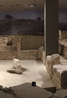
The mound of Çayönü; which used to be called Kotaberçem or Çayboyu; lies northwest of the city of Diyarbakir; 7 km southwest of the town of Ergani. It has been suggested that there was a large flood in the Aceramic Neolithic Period which split the mound in two. The alluwial silt of the river; which meanders around the northern part of the mound; has created a terrace. Evidence shows that the Ceramic Neolithic settlement at the site was here. The site of Çayönü; where there was continuous habitation from the Aceramic Neolithic (10.000 BCE) to the Middle Ages; is comprised of Aceramic Neolithic; Ceramic Neolithic; Chalcolithic; Early Bronze Age; second millennium; Iron Age and Medieval settlements.
- Tushhan, Diyarbakır
- Ancoz, Adıyaman
- Samosata (Capital of Commagene), Adıyaman
- Tille, Adıyaman
- Altıntepe, Erzincan
- Antiochia and Taurum, Gaziantep
- Carchemish (Capital of Neo Hittite confederation), Gaziantep
- Sakçagözü, Gaziantep
- Samal, Gaziantep
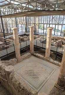
Zeugma, Gaziantep
The ancient site of Zeugma was once an important city of the Kommagene Kingdom. It is situated some 50 km east of Gaziantep, on the banks of the Euphrates. Its name derives from the bridge of boats that in ancient times connected the riverbanks, forming one of the major river crossings of the region. The significant part of this archaeological site is now lost under the waters of the Birecik Dam, and its most spectacular finds, especially the magnificent mosaics are now displayed in the Zeugma Mosaic Museum in Gaziantep. Zeugma was founded by Seleucos I, one of the generals of Alexander the Great who fought for control over his empire after his death in 323 BCE. In ancient times, the name Zeugma encompassed the twin cities, on both banks of the Euphrates. The western town was also known as Seleucia after the founder, while the eastern settlement was called Apamea as Seleucus' wife Apama. Recent Turkish excavations unearthed another residential area with mosaics and this area is roofed, allowing a pleasant visit. The site, being next to the dam, has a magnificent view as well.
Dara, Mardin
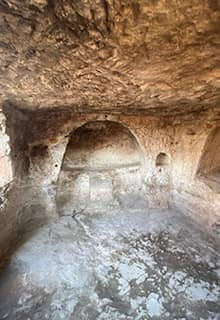
Dara is located 30 km Southeast of Mardin, which is one of the most attractive settlements in the area. The ancient name was Anastasiapolis. Dara has been one of the most important trade centers of Mesopotamia for centuries. The city witnessed wars of the Persian Emperor Darius and Alexander the Great. When Persians conquered Nusaybin in 363 CE, this place became the border of the Roman Empire. The city was strengthened by Emperor Anastasius in 5th century CE as a border outpost and was taken into control by Persians once again 100 years later. Dara city that is composed of structures carved on rocks, cemeteries in the eastern part and the city is protected by 4 km of city walls. A visitor to Dara enjoys, churches, palaces, markets, dungeons, armories, cisterns, and water jumps. A giant cistern built by carving the rocks perhaps is the most interesting structure in Dara.
- Antiochia, Şanlıurfa
- Apamea on Euphrates, Şanlıurfa
Edessa, Şanlıurfa
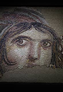
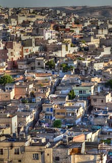
Şanlıurfa, ancient Edessa is one of the most important cities of Southeast Türkiye and located at the headquarters of Mesopotamia. Mesopotamia means “the middle of two rivers” those are Euphrates and Tigris. It has always been a main crossroads from lower Mesopotamia to Anatolia. It was founded during the Hellenistic period by King Seleucus I in the 3rd century BCE, It later became capital of the Kingdom of Osroene, and continued as capital of the Roman province of Osroene. However, recent excavations revealed that, like the surroundings of Şanlıurfa, the city center al goes back to early Neolithic period, and famous Urfa Man, displayed in the museum is a witness of this period. During the Late Antiquity, it became a prominent center of Christian learning and seat of the Catechetical School of Edessa. The city was a center of Greek and Aramaic (Syriac) theological and philosophical thought, hosting the famed School of Edessa. To Muslims, the old city had a special significance, because of a local legend that tells the prophet Abraham was born in a cave near the fortress of Edessa. Another legend tells that the evil king Nimrod wanted to punish Abraham and threw him from the citadel into the fire. The fire, however, changed into a pool of water and the logs of wood into fish, which are venerated until the present day.
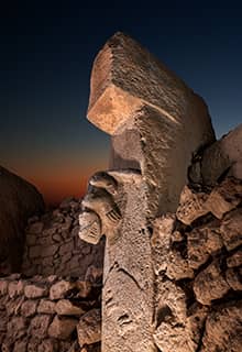
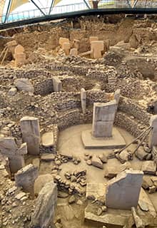
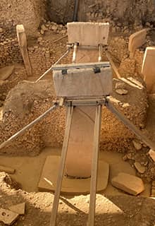
Göbeklitepe, Şanlıurfa
Göbeklitepe is perhaps the most known and speculated archaeological site especially in the last 10 years. It was discovered in 1990s, and excavations are ongoing since then. Göbeklitepe is about 20 km Northeast of Şanlıurfa. The colossal anthropomorphic statues are extraordinary for this period of mankind which date back to 11.000 12.000 BCE. Before Göbeklitepe the history of Neolithic period only begun around 9000 BCE, however, the colossal statues and several reliefs on the statues are unique for this period. It is understood that Göbeklitepe was a kind of shrine, consisting of round rooms, each containing these colossal statues. According to some scholars, this is a cult area where rituals were performed for the death and underworld, for the sake of ancestor cults. There is no ceramics, nor signs of any settlement here, however, the giant project that was carried out at Göbeklitepe, recalls a very sophisticated and organized society inhabited in the close vicinity. Surprisingly, the Göbeklitepe shrines were not buried by natural causes, but, were buried by people who lived here on purpose, the reason remains as a mystery. Recent surveys in the area showed that there are several similar shrines / structures in the area from the same period.
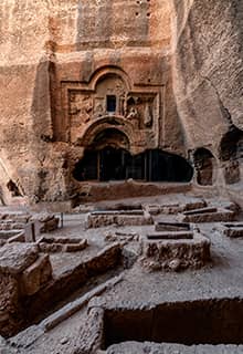
Harran, Şanlıurfa
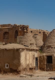
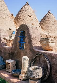
Harran is situated 50 km south of Şanlıurfa, almost on the Syrian border. Harran was called Carrhae in the Roman period. It was always of strategic importance being located on the road that ran from Nineveh to Carchemish and was regarded as of considerable importance by the Assyrian kings. Its main cult in Assyrian times was that of the moon god. It is frequently mentioned in the Bible; Abraham’s family settled there when they left Ur of the Chaldeans. In Roman times, it was the scene o f a disastrous defeat of the Roman governor Marcus Licinius Crassus by the Parthians in 53 BCE and of two later battles between the emperor Galerius and the Persian king Narses. Earliest settlement goes back to the 7th millennium on the site. The earliest historical records go back to Ebla tablets in the 3rd millennium BCE, it is known that an early king of Harran married an Eblaite princess, Zugalum, who then became "queen of Harran", and whose name appears in a number of documents. During the late 8th and 9th centuries, Harran was a center for translating works of astronomy, philosophy, natural sciences, and medicine from Greek to Syriac by Assyrians, and thence to Arabic, bringing the knowledge of the classical world to civilization in the south. Baghdad came to this work later than Harran. Many important scholars of natural science, astronomy, and medicine originate from Harran. Today, most visitors admire the beehive shaped local houses of this area made out from mud brick.
Nevalı Çori, Şanlıurfa
Before Göbeklitepe was excavated and became famous, Nevalı Çori was already excavated with almost exact same material from the same period. The orginal site is now under the dam, however, colossal statues and other finds from Nevali Çori that date back to 10.000 BCE, are on display in the new Şanlıurfa Museum.
- Sultantepe, Şanlıurfa
Zerzevan Castle, Diyarbakır
Zerzevan castle is located some 65 km south of Diyarbakır, at the village of Demirölçek. Archaeological excavations at the site revealed underground structures, a temple of Mithraism, an interesting religion especially common in Persia. The castle was used as a civilian settlement between the 1890s and the 1960s. Zerzevan Castle was built in the 4th century CE, as a military base on the ancient trade route between Diyarbakır and Mardin. It was used until the 7th century. In 2020, archaeologists found the entrance of the castle. The castle contains structures both above and below ground. Inside the castle, there are ruins and a necropolis. Other public buildings include the palace, administrative building, baths, wheat storage, arsenal, and several cisterns. The place was known as Samachi in classical times.
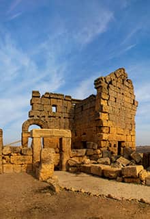
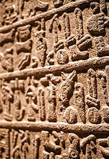
Karkamış, Gaziantep
Karkamış is located 75 km Southwest of Gaziantep, just on the Syrian border. The site was closed for visitors for several years due to political problems with Syria, now opened to the visitors as these problems are solved. Carchemish was an important settlement even before the 2nd millennium BCE when it remained under Mitanni- Hurri rule during the 15th and 14th centuries, and then came into Hittite control during Suppiluliuma I in the 14th centıru BCE. After the collapse of the Hittite Empire around 1180 BCE, Karkamış survived as one of the several smaller Neo-Hittite kingdoms established in southeast Anatolia and northern Syria. It was an important trade center and reached its peak around the 9th century BCE. All monumental finds date to the Neo-Hittite period, first millennium BCE, Karkamış consisted of a high citadel mound by the Euphrates with a walled inner town and an outer town. Excavations revealed a processional way which led to the temple of the Storm-God and to a monumental stairway to the citadel. The whole complex was decorated with basalt and limestone sculptures. Most of the orthostats and statues from early excavations are currently in the Anatolian Civilizations Museum in Ankara. Several other artifacts are in the British Museum. Findings from the recent excavations are either kept at the site or transferred to the Gaziantep Archaeology Museum.
Doliche, Dülük, Gaziantep
Doliche is located in the southern part of Gaziantep, at Şehitkamil district of the city. Finds in the mound of Dülük include stone tools from 30-40 thousand years ago. During the Hittite period, it was an important stop on the main road connecting the Mediterranean to Mesopotamia. It was also a religious center and the sanctuary of the Hittite god Teshub was just to the north of the village. Doliche once belonged to the ancient region of Cyrrhestica, and was ruled by the Kingdom of Commagene. Archaeological finds in Doliche include an underground Mithraic temple, rock graves and stone quarries from which giant rock blocks are produced.
Yesemek Quarry and Sculpture Workshop, Gaziantep
Yesemek is a unique site located on the Syrian border, some 200 km east of Adana on the way to Gaziantep. It is a Hittite sculpture workshop containing precious sculptural material some are half finished. Yesemek was the largest stone quarry and statue-processing worksite of Near East during the 2nd millennium through 8th century BCE. Everything stayed still and the time is like frozen till 1890. In the open-air museum where nearly 300 sketch pieces of statues were excavated and exhibited in an order. Most of the sketches are constituted by gate lions.
Karahantepe, Şanlıurfa
Karahantepe is located 60 km east of Şanlıurfa. It is interesting that there were so many Neolithic places in a very close vicinity, such as Göbeklitepe, Karahantepe, Nevali Çori are are located almost in the same area. Recent archaeological work suggests that Karahantepe might be even earlier than Göbeklitepe, and this is places the site to be the earliest known Neolithic site in the world. Just like in Nevali Çori and Göbeklitepe, Karahantepe also has a similar layout, and “T” shaped obelisks, so far around 250 of them were unearthed. As part of the “Göbeklitepe Culture and Karahantepe Excavations” project, surface surveys were initiated two years ago by İstanbul University in the area, known as “Keçilitepe” by the people of the region. The works are headed by Professor Necmi Karul. Karahantepe and all Şanlıurfa area, keeps changing the known history of the world.
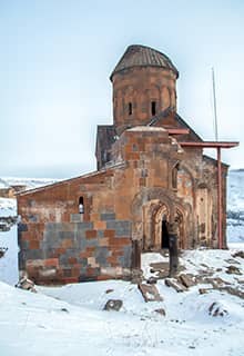
Ani, Kars
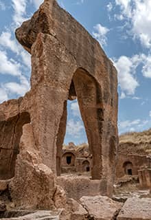
Ani is located 50 km east of Kars, at the Armenian border where river Arpacay forms the border. Arpacay river also adds a lot to the Eastern Anatolian landscape. Ani was once a great metropolis, known as "the city of a thousand and one churches." The city was the capital city of Bagratid Armenian Kingdom from the 10th century CE. Ani is situated on trade routes and grew to become a walled city of more than 100,000 residents by the 11th century. In the centuries that followed, Ani and the surrounding region were conquered by Byzantine emperors, Ottoman Turks, Georgians, and Russians claimed the area, repeatedly attacking and chasing out residents. By the 1300 CE, Ani was in steep decline, and it was completely abandoned by the 1700. Today most of the churches are still standing to a sufficient height, the streets, baths, an early Mosque, and the great fortification walls are impressive.
- Cyrrus, Kilis
Tushpa (Capital of Urartu), Van
Tushpa is modern town of Van, and was the 9th century BCE capital of Urartians, name Van is derived from Biainili, the native name of Urartu. The ancient ruins are located just west of Van and east of Lake Van. Tilkitepe mound excavations revealed that human settlement started in the area as early as 5000 BCE. Urartians were a people who live during the same period with the Phrygians and created perhaps the most important civilization of eastern Türkiye in this period. There has been a speculation about the Urartian language being an early form of Armenian, however, linguistically, there is no connection between them. Most the remarkable ruins are in and around the Van castle, which is a beautiful place to visit. Visitor also keep in mind about the famous Van breakfast and should enjoy one of the restaurants who serve Van breakfast.